Understanding Tornadoes: Causes, Stages, and Warning Signs

Tornadoes are among the most powerful and destructive weather phenomena on Earth. Known for their unique tubular shape, violent wind speeds and rapid development, they have fascinated and terrified humans for centuries. Understanding what tornadoes are, how they form, and where they strike can help you prepare for these swirling giants of nature.
What is a Tornado?
A tornado is a rapidly rotating column of air that extends from a thunderstorm to the ground, and can reach wind speeds over 200 miles per hour. More violent twisters are capable of obliterating buildings, lifting vehicles, and uprooting trees. Most are relatively short-lived, lasting only a few minutes, but in some rare cases they can persist for over an hour and travel dozens of miles.
What Conditions Cause Tornadoes to Form?
Tornadoes typically form under conditions that are most common during severe thunderstorms, including:
- Warm, moist air near the surface, typically originating in the Gulf of Mexico when it comes to tornadoes in the U.S.
- Cool, dry air aloft, often from the Rocky Mountains and Canada.
- Strong wind shear, meaning a significant change in wind speed and direction with altitude.
- Atmospheric instability, where warm air rises quickly into cooler upper layers
These ingredients together create an environment ripe for intense thunderstorms and, occasionally, tornadoes. In the United States, tornado season is typically marked as April to June, especially in “Tornado Alley”, as that is the time of year with the biggest contrast in temperature and humidity levels between the Gulf of Mexico & Rocky Mountains.

How do Tornadoes Form?
The formation of a tornado is a complex process involving several steps:
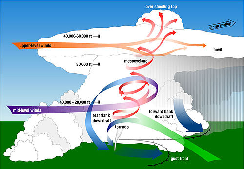
- Development of a Supercell Thunderstorm: These storms have a rotating updraft known as a mesocyclone.
- Wind Shear and Rotation: Wind shear causes horizontal tubes of rotating air. As the storm strengthens, these horizontal tubes can be tilted vertically by the updraft.
- Formation of a Funnel Cloud: The rotation tightens and intensifies, forming a visible funnel as moisture condenses. This funnel cloud may or may not reach the ground. This is the visible part of a tornado that gives it such a distinct and intimidating appearance.
- Touchdown: If the funnel cloud descends and makes contact with the ground, it officially becomes a tornado.
How and Why Tornadoes Dissipate
Tornadoes eventually weaken and dissipate due to changes in the storm’s structure or environment. Like a hurricane, thunderstorms and tornadoes get their energy from warm, moist air. This means the most common cause for a tornado to dissipate is that it simply runs out of energy when there isn’t enough of that humid air left to fuel the storm or supercell.
Supercells also create a downdraft of dry air behind them as they move, called a rear flank downdraft, and sometimes that downdraft can wrap around the front of the supercell and disrupt the mesocyclone, ending the tornado. Without the proper inflow of air and structure, the tornado loses its strength, narrows, and eventually disappears.
 Tornado Hotspots in the United States
While tornadoes can occur in many parts of the world, the United States experiences more tornadoes than any other country. The most tornado-prone area is known as Tornado Alley, which includes South Dakota, Nebraska, Kansas, Oklahoma and parts of Texas.
However, tornadoes are not confined to Tornado Alley. States in the Southeast, such as Alabama and Mississippi, are also frequent targets, particularly during the spring and fall tornado seasons. These regions have even been dubbed “Dixie Alley” due to the increasing frequency and severity of tornado outbreaks there.
Weather Instruments that Predict Tornadoes
Because tornadoes form so rapidly, and require so many different conditions to come together at the same time, predicting them is an inexact science. Tools like Doppler radar and weather satellites are best for picking up the rotational aspect of a thunderstorm turning into a supercell, and later a tornado.
An instrument like a barometer will predict changes in atmospheric pressure, so it can help predict when thunderstorms are coming. A rapid drop in pressure indicates that a storm is coming, and the faster and further the pressure drops, the more severe the storm will be. Anemometers can also be used to track rapid changes in windspeed, which can be indicative of a tornado on the way, and are also used to measure the windspeeds that a tornado generates. However, there’s good reason that so many U.S. cities have tornado sirens to warn residents of an impending tornado, as they are very difficult to predict until mere moments before they’re formed.
Final Thoughts
Tornadoes are a complex and awe-inspiring weather phenomena that meteorologist are still studying as they are not understood to a 100% degree of certainty. The pure destructive power that they possess is evident every year, so awareness and preparedness remain key, especially in tornado-prone regions. By respecting their power and staying informed on changing weather conditions, you can keep yourself saf