El Niño and La Niña are two phases of the climate phenomenon known as the El Niño-Southern Oscillation (ENSO). These phases occur in the tropical Pacific Ocean and have significant impacts on global weather patterns, particularly in the United States. While El Niño and La Niña are opposite in nature, they both have the power to influence seasonal weather conditions, ocean temperatures, and atmospheric circulation. Understanding the differences between these two phenomena is crucial for predicting weather changes, especially in regions like the U.S. where they can cause dramatic shifts in rainfall, temperatures, and storm patterns.
What Is El Niño?
El Niño is characterized by the warming of sea surface temperatures in the central and eastern equatorial Pacific Ocean. Typically, trade winds blow from east to west across the Pacific, pushing warm surface waters toward Asia, which allows cooler water to rise to the surface near the Americas. During El Niño, these trade winds weaken, and the warm water spreads eastward, leading to higher ocean temperatures off the coast of South America. This warming affects weather patterns not only in the Pacific region but also across the globe.
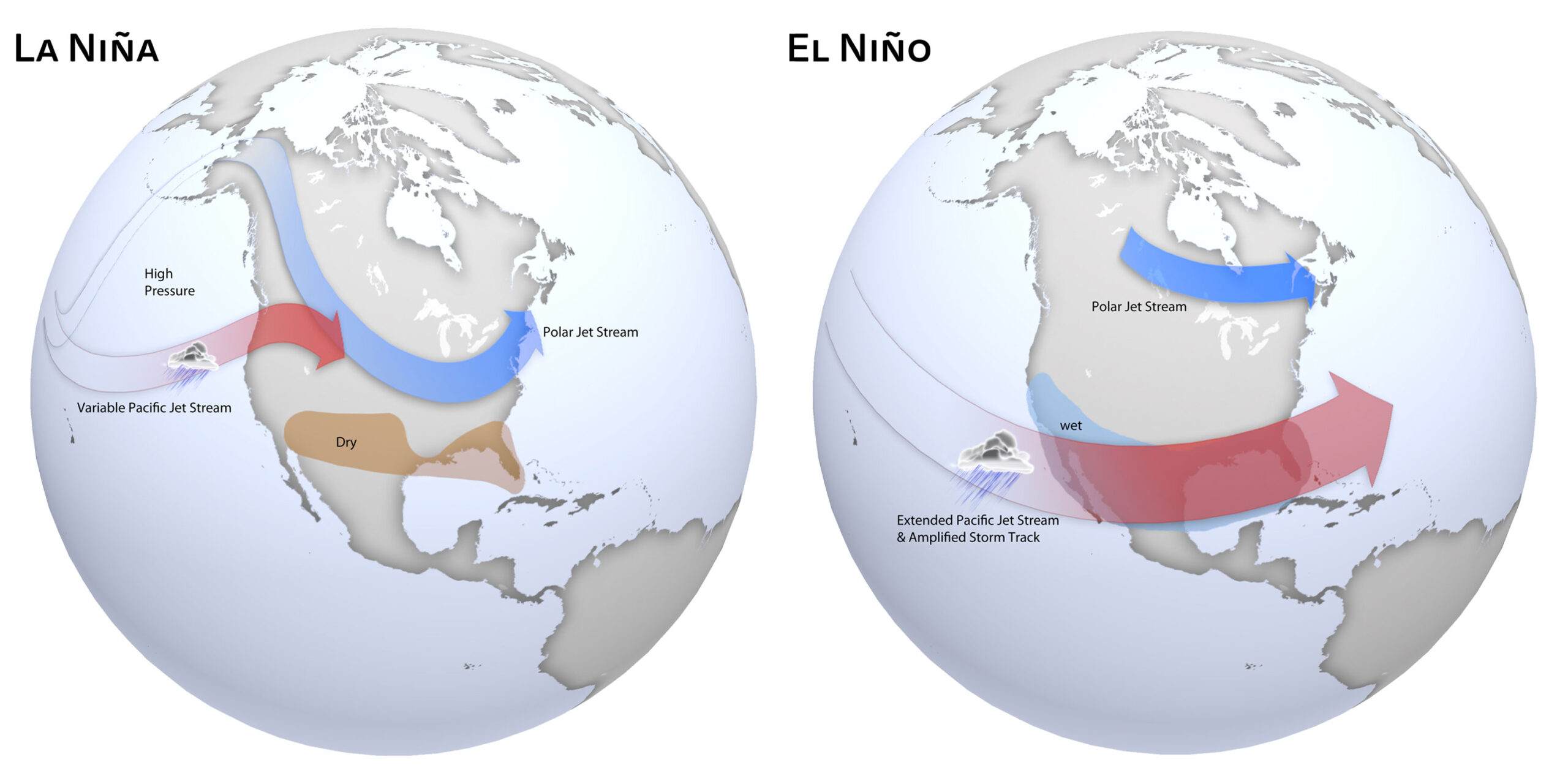
In the U.S., El Niño usually brings wetter conditions to the southern part of the country, particularly during the winter months. States like California, Texas, and Florida often experience increased rainfall and a higher risk of flooding. On the other hand, El Niño typically leads to drier and warmer conditions in the northern part of the U.S., including the Pacific Northwest and parts of the Midwest. This phase can also reduce the frequency and intensity of Atlantic hurricanes due to increased wind shear in the Atlantic basin, which disrupts storm formation.
(El Niño)
What Is La Niña?
La Niña, the opposite of El Niño, occurs when sea surface temperatures in the central and eastern Pacific cool below normal. During La Niña events, trade winds strengthen, pushing warm water farther west and allowing cooler waters to upwell along the South American coast. This cooling of the ocean surface alters atmospheric circulation patterns and causes significant changes in global weather.
In the United States, La Niña typically leads to cooler and wetter conditions in the Pacific Northwest, as well as increased snowfall in northern states. The southern U.S., in contrast, experiences drier and warmer-than-average conditions during La Niña winters. This phase also tends to create favorable conditions for hurricane formation in the Atlantic, as the cooler Pacific waters contribute to weaker wind shear, allowing hurricanes to develop more easily and intensify.
Key Differences Between El Niño and La Niña
Sea Surface Temperatures
El Niño warms sea surface temperatures in the central and eastern Pacific Ocean, while La Niña cools sea surface temperatures in the same region.
Trade Winds
El Niño weakens or reverses the normal easterly trade winds, causing warm water to shift eastward. Conversely, La Niña strengthens the trade winds, pushing warm water westward.
Impact on Hurricanes
El Niño reduces hurricane activity in the Atlantic due to increased wind shear in the Atlantic Basin, while La Niña increases the likelihood of hurricanes by reducing that wind shear.
 The Science Behind El Niño and La Niña
While the terms El Niño and La Niña are commonly used to describe shifts in weather patterns, they are fundamentally tied to complex atmospheric and oceanic interactions. These phenomena are a part of the El Niño-Southern Oscillation (ENSO) cycle, a natural fluctuation in the Earth’s climate system that occurs over a period of three to seven years. ENSO consists of three phases: neutral, El Niño, and La Niña. The shift between these phases is driven by changes in the sea surface temperatures of the Pacific Ocean and the winds that influence them.
Understanding the mechanisms behind these phases can help us better predict their effects on the environment. During an El Niño event, the reduction in trade winds disrupts the typical oceanic and atmospheric conditions, allowing warm waters to spread across the Pacific. This in turn alters atmospheric pressure systems, including the location and movement of the jet stream. Conversely, La Niña events occur when the trade winds intensify, further pushing warm water westward and leading to the cooling of the central Pacific Ocean. This atmospheric disruption causes a series of atmospheric changes that have global weather repercussions.
How Ocean Temperatures Influence the Jet Stream
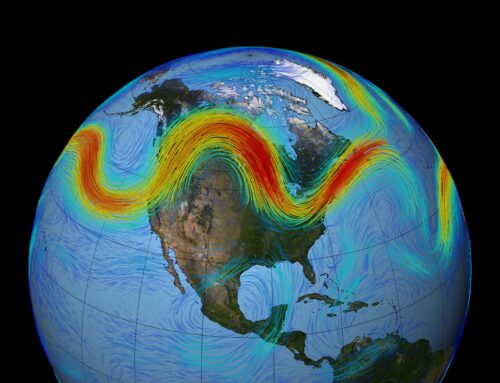
The shift in ocean temperatures during both El Niño and La Niña events has a significant impact on the jet stream, which in turn influences weather patterns across North America. During El Niño, the warmer waters cause the jet stream to dip southward, pulling wetter, stormier air into southern U.S. states, while pushing the northern regions into a drier, milder pattern. In La Niña, the cooler ocean temperatures push the jet stream northward, contributing to a drier and warmer southern U.S. but wetter conditions further north.
Preparing for the Impacts of El Niño and La Niña
Understanding the specific impacts of El Niño and La Niña can help communities better prepare for the potential weather changes each phase brings. Since these events can often bring extreme weather, it is important for residents, especially in high-risk areas, to take precautions before severe conditions strike.
Preparing for El Niño-Related Flooding
During El Niño, the increased rainfall and storms can lead to severe flooding in places like California, Texas, and Florida. Homeowners in flood-prone areas should consider investing in flood insurance and preparing homes with storm-resistant infrastructure. This includes securing roof structures, installing sump pumps, and ensuring that drainage systems are clear to handle the influx of rainwater. Communities in these regions may also want to reinforce flood barriers and stockpile emergency supplies to be ready for potential evacuations.
Planning for La Niña’s Cold and Snowy Winters
On the other hand, La Niña’s impacts on the Pacific Northwest and Midwest U.S. bring colder temperatures and increased snowfall. In these areas, residents should prepare for harsh winter conditions by winterizing homes, ensuring proper insulation, and stocking up on emergency heating supplies.
For those with boats in regions impacted by La Niña’s colder weather, winterizing your boat is an essential step. Just as homes need to be insulated, boats require proper care to protect them from freezing temperatures. This includes draining water systems, adding antifreeze to the engine, and covering the boat to prevent damage from snow or ice. Winterizing your boat not only ensures its longevity but also protects it from costly repairs come spring.
How El Niño & La Niña Affect Weather in the United States
El Niño has a profound effect on weather patterns in the U.S., particularly during the winter months. One of the most significant impacts is the shift in the jet stream, a fast-moving air current that influences weather systems. During El Niño, the jet stream tends to move farther south, bringing stormier and wetter conditions to the southern U.S., while the northern U.S. often experiences drier and milder weather.
La Niña, being the opposite phase of ENSO, has an opposite affect on weather in the U.S. The strengthening of the trade winds pushes the jet stream farther north, altering the distribution of precipitation and temperature patterns across the country.
California and the southwestern U.S. typically see more frequent and intense rainstorms during El Niño events than during La Niña. This increased precipitation can help alleviate drought conditions but also raises the risk of flooding, landslides, and other weather-related hazards.
States like Florida and the Gulf Coast region may also experience wetter-than-average conditions during El Niño events. However, the same effect that brings more rain also tends to suppress Atlantic hurricane activity.
La Niña events typically bring wetter and cooler conditions to the Pacific Northwest and Midwest, which can lead to flooding in some areas while colder areas will experience increased snowfall and harsher winters.
 (La Niña)
Long-Term Impacts of El Niño and La Niña
Beyond the immediate weather disruptions, both El Niño and La Niña have lasting effects on ecosystems, agriculture, and economies. These weather events can create long-term droughts or lead to the depletion of water resources, which may affect farming and water supplies for years to come.
Impact on Agriculture and Water Resources
El Niño can exacerbate drought conditions in the northern U.S. and parts of South America, reducing agricultural productivity. In contrast, La Niña can lead to excessive rainfall in certain regions, creating flooding that damages crops and disrupts food supplies. The shifting availability of fresh water can also impact irrigation systems and increase competition for water resources, especially in areas reliant on snowpack from the Rockies or Sierra Nevada. Farmers may need to adapt by diversifying crops or using more efficient irrigation systems to deal with these fluctuations.
Conclusion
El Niño and La Niña are powerful climate phenomena that have far-reaching impacts on global and U.S. weather patterns. While they represent opposite phases of the ENSO cycle, both have the ability to influence precipitation, temperatures, and storm activity in significant ways. These fluctuations are essential for meteorologists to monitor, as they help predict seasonal weather changes and prepare for potential impacts such as flooding, droughts, and hurricanes. Understanding these patterns can help communities plan for the year ahead and mitigate weather-related risks.


 The Science Behind El Niño and La Niña
 (La Niña)


